LiDAR from Space: An X-Ray for the Earth
Taofiq Huq, founder of Spiral Blue, explains how lasers and space edge computing are being used to scan forest structures, measure biomass, and help solve global environmental challenges. He explains how LiDAR (Light Detection and Ranging) is like an “x-ray machine” for Earth, using lasers to pierce through clouds and smoke to create highly detailed 3D maps, providing vital data for environmental conservation and disaster management.
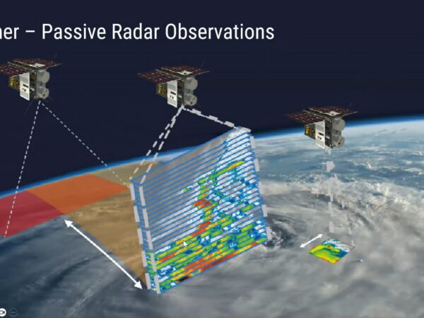
[00:00:12] LiDAR is essentially a metaphor for an x-ray machine in orbit. By emitting pulses of light from onboard lasers, satellites can scan the Earth from hundreds of kilometers away. These pulses bounce back to the satellite, allowing scientists to see what is happening inside forests and create precise 3D maps of the terrain.
Measuring Biomass and Carbon
[00:01:02] This technology is a game-changer for environmental monitoring. LiDAR can accurately measure biomass, biodiversity, and the amount of carbon captured in a forest. It also helps assess bushfire risks and monitor coastal erosion. Because the lasers can penetrate the canopy, they provide “ground truth” data that standard satellite photography often misses.
[00:15:50] Governments and commercial companies use this data to prove they are meeting their environmental goals. Planting forests is the easiest way to capture carbon from the atmosphere, and space-based LiDAR is the fastest, most cost-effective way to scan that land and verify tree growth over time.
Space Edge Computing: Processing at the Frontier
[00:01:22] Spiral Blue’s technology is built on “Space Edge Computing.” This consists of small computers—about the size of your hand—that run AI and machine learning directly on the satellite. This homegrown Australian technology has already been deployed on nine satellites, allowing data to be processed in orbit before being sent back to Earth.
[00:06:03] Edge computing places the processing power at the “frontier” of the network. By analyzing the raw data in space, the satellite only needs to send back the most important information, saving bandwidth and reducing the time it takes to deliver insights to customers on the ground.
Piercing Through Smoke and Haze
[00:18:14] Because LiDAR uses high-power lasers, it can pierce through haze, smoke from bushfires, and thin layers of fog. When the laser pulses pass through these objects, some light bounces back, allowing the satellite to measure the particulates in the air while still capturing what is happening on the ground beneath the smoke.
Taofiq’s Journey: From Backyard Boats to Space
[00:09:05] Taofiq describes his path as an obsession with building things—including attempting to build hovercrafts in his backyard as a kid. He eventually pursued aerospace engineering at UNSW, though he notes that today’s space industry also needs experts in marketing, law, architecture, and psychology.
[00:12:25] His advice for the next generation? Focus on making friends and building trust. “We don’t build alone,” Taofiq emphasizes. The friendships you make in the industry are the foundation for everything you will eventually build.
Home » Articles »