AquaWatch: Monitoring Our Waterways from Space
Dr. Leo Lymburner explains how the AquaWatch program uses satellite imagery and big data to monitor water quality, detect algal blooms, and protect our lakes and streams. By processing petabytes of space-based data, scientists can now predict harmful algal blooms and help people make better decisions about how they interact with nature.
[00:00:10] Dr. Leo Lymburner works with CSIRO’s AquaWatch program. To explain the importance of his work, he tells the story of “Dave the Paddler,” a camper who accidentally picks a lake filled with toxic algae because he lacked real-time information. Dr. Lymburner’s goal is to use satellite data to ensure no one else has to make that mistake.
Seeing Water Quality from 800km Up
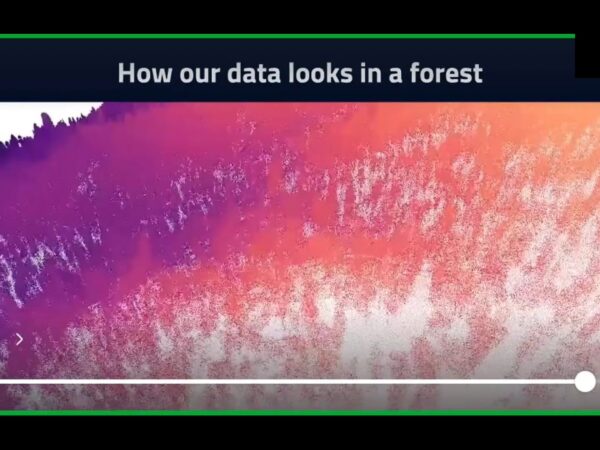
[00:01:46] Using satellites like Sentinel-2, operated by the European Space Agency, scientists can get a 10-meter resolution view of any waterway every five days. By looking at “true color” images, we can see water levels dropping and the color shifting to green—a clear indication of chlorophyll and potential algal blooms.
[00:02:32] Australia has hundreds of thousands of waterways and petabytes of satellite imagery. To monitor them all, scientists use Jupyter Notebooks and Python code to automate the process. This allows them to “wrangle” massive volumes of data into a single, usable object for analysis.
The Formula for Clean Water
[00:03:40] The AquaWatch method follows a specific technical workflow:
- Find the Water: Create a digital outline (polygon) of the water body.
- Detect Wet Pixels: Use a remote sensing index to find exactly where the water is at different points in time.
- Measure Chlorophyll: Analyze specific wavelengths of light that show where photosynthesis is occurring in the water.
- Set Thresholds: Determine when the chlorophyll levels reach a “Red Alert” state, indicating the water is dangerous for humans or pets.
Beyond the Science: Software and UI Design
[00:05:12] Collecting the data is only the first step. To help people like Dave, the workflow must be transferred to a large-scale processing system that updates automatically with every satellite overpass. This requires **software engineers** to manage the data analytics and **UI/UX designers** to create the phone apps and web portals where users actually access the information.
[00:06:41] This technology isn’t just for recreation. It helps water utilities predict harmful blooms in drinking water reservoirs, allowing them to start treating the water before the bloom even begins. State agencies also use this data to decide which lakes need to be closed to the public for safety.
Get Involved: Digital Earth Australia
[00:08:01] If you want to try satellite processing yourself, the Digital Earth Australia portal offers beginner guides and notebooks. These resources teach you how to load data and perform basic analysis. You can even use tools like AI to help you learn the Python code needed to start making your own discoveries from space.
Home » Articles »